
One of the most versatile and powerful sensor systems, becoming standard kit for surveyors and reality capture practitioners, is Handheld SLAM. However, there have been few practical guides published. This one is timely, comprehensive, and very well put together. Even experienced SLAM jockeys could find this helpful.
Download this new guide. It deftly captures (no pun intended) how it works, best practices, and how to train your operators.
Here are some highlights:
- Overview of SLAM technology and how the sensor fusion in these systems works.
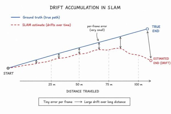
- Understanding and managing trajectory drift and degeneracy (i.e., how environments like long corridors, large open spaces, plain walls and glass, and dense foliage can cause a kind of “snow blindness”).
- Loop closures, leveraging RTK (for outdoor scanning), and how to handle outdoor-indoor transitions.
- Handling the device in a manner that will not block or disrupt collection.
- System initialization best practices.
- Setting and working with ground control points (GCP).
- Realistic performance expectations—what it can do and cannot do. Distance limitations.
- Sensor pre-capture checklists, lens and sensor hygiene, power and storage management, firmware, RTK+NTRIP setup, and best practices for operation: 10 Golden Rules.
- Common scanning scenarios and recommended best practices for each. Plus, common pitfalls and mistakes in both capture and data processing, and what to do to recover from various failure modes.
- And a bonus that many guides do not address: Recommended training curriculum to self-certify your SLAM operators.
Recently, a colleague asked me where to find SLAM guidelines, and this one hit my inbox. Hats off to Tersus for putting this together and for presenting it in a generic manner; this guide could be used for any handheld SLAM system. They did not use it as a vehicle to promote their own gear, though they do have an impressive portfolio of reality capture and positioning gear.
Beep on!


Be the first to comment