It looks as though the Canadian federal government, through NRCAN, is going to take a long hard and very expensive look at the Canadian geomatics industry. They have issued a request for proposals (RFP) for a “CANADIAN GEOMATICS ENVIRONMENTAL SCAN AND ECONOMIC VALUE STUDY.” You can find it on the MERX system. For those in the know, that’s the system where the government and industry place request for proposals. Let’s take a closer look at this.
The RFP was put out on the 24th of August and will be open until October 3rd 2012. It’s a very large project as they have it pegged at an estimated value between $500,001 – $1,000,000. That’s a very serious amount of money.
Here is the notice description of the study from MERX:
Geospatial information is generated and used within the framework of the national system of innovation, a system Canada must strengthen and deepen in order to remain competitive in a changing world. Just how geospatial information affects this innovation system is a key issue to be determined; as is the need to assess the make-up of the geospatial supply-chain, the geomatics sector, within this system of innovation.
To gain this knowledge, Natural Resources Canada is soliciting proposals to conduct a two-part study consisting of a Canadian Geomatics Environmental Scan and a related Economic Value Study, which will be carried out over a one year time frame and in sequential order. Given the subject and nature of the proposed study, consortium bids are encouraged to ensure sufficient qualified expertise are available (MERX)
What does it all mean? Well it means that the feds are taking geomatics in Canada seriously. They are trying to figure out what is going on in our sector. It sounds like they are trying to get a baseline as to where we are, and then what are the best approaches to support growth. It’s a good idea. Canada is seeing a lot of growth in this sector.
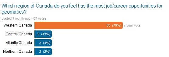
Much of the growth in geomatics is in the west and that will move north as our northern territory opens up with more development. Natural resources are driving a lot of this growth. Recently, GoGeomatics Canada ran a poll on our GoGeomatics Canada Linkedin group of professionals that speaks towards the growth in the west.
The size of the RFP leads us to believe the government is looking for the larger consulting companies to put in proposals. Industry insiders tell GoGeomatics Canada that consulting groups like KPMG, Fujitsu, and Hickling are the best placed to go after this and submit proposals. They are expecting some consortium bids. So if a savvy group of professionals think they can pull it off we may see some new contenders in this market.
Don’t expect to hear anything about this study for a good long time. It’s going to take over a year to do and then the government might sit on it for a while. You never know. It’s encouraging to see the government taking an interest and starting to move in the right direction.


Be the first to comment